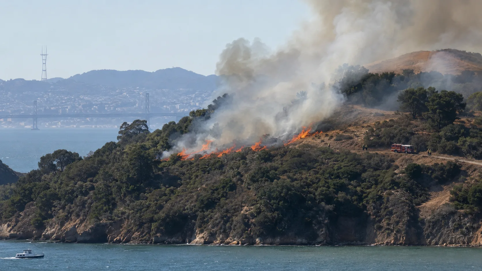

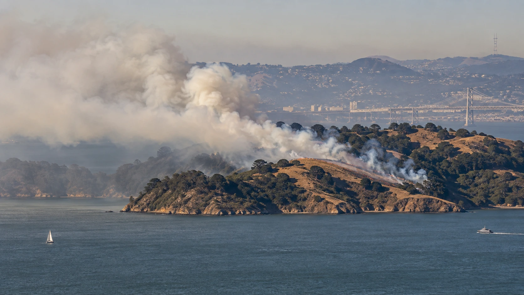
What is the smoke over San Francisco Bay? The visible fire on Angel Island on September 8, 2026 is a planned prescribed burn, not an uncontrolled wildfire. The operation began around 10:30 a.m. PDT and is designed to treat up to 260 acres of grassland and coastal scrub. California State Parks is conducting the project with CAL FIRE and the Marin County Fire Department.
A large smoke column rising from Angel Island became visible from San Francisco, Sausalito, Tiburon and other parts of the Bay Area Tuesday morning, prompting searches for “Angel Island fire,” “fire on Angel Island” and “Bay Area fire.”
The smoke is expected. State and county officials announced the operation in advance and specifically asked residents not to call 911 simply to report smoke from the island, because the burn is being managed by fire personnel and unnecessary calls can overwhelm emergency dispatchers.
In this article:
- Is Angel Island on fire today?
- Why officials are intentionally burning the island
- Where smoke can be seen and how long it may last
- Why officials say not to call 911 about the smoke
- Park, trail and Mount Livermore closures
- How a prescribed burn is kept under control
- Angel Island fire video
- Where to get official updates
- Frequently asked questions
Is Angel Island on Fire Today?
Yes, but it is not being reported as a wildfire emergency.Fire crews intentionally ignited a prescribed burn on Angel Island on Tuesday, September 8.
Local reporting placed the start of Tuesday's operation at approximately 10:30 a.m. PDT. The planned treatment area is up to 260 acres, although the amount actually burned can depend on conditions during each operational period.
| Operation | Angel Island State Park prescribed burn |
| Started | September 8, 2026, around 10:30 a.m. PDT |
| Maximum planned treatment | Up to 260 acres |
| Fuel types | Grassland and coastal scrub |
| Lead / partner agencies | California State Parks, CAL FIRE, Marin County Fire Department |
| Air-quality coordination | Bay Area Air Quality Management District |
| Park status | Park remains open, with temporary closures near burn operations |
| Emergency? | No uncontrolled wildfire emergency has been reported in connection with the planned burn |
The project may continue later in the week if weather, fuel moisture and air-quality conditions remain within the approved prescription. Fire managers can delay or stop ignition if conditions are not suitable.
Why Are Firefighters Burning Angel Island on Purpose?
Prescribed fire is used to change vegetation and reduce fuel under controlled conditions before an uncontrolled wildfire occurs.
California State Parks says the Angel Island project has several objectives:
- Reduce fuel loads in grasslands and coastal scrub.
- Improve wildlife habitat by maintaining fire-adapted vegetation communities.
- Control invasive vegetation and reduce non-native plants that compete with native species.
- Support long-term vegetation stewardship on the island.
- Reduce future wildfire severity by removing some dry vegetation while crews, weather and resources are deliberately planned in advance.
The operation is part of California State Parks' Prescribed Burn Program and is supported by Proposition 4, the 2024 Climate Bond.
State Parks has used prescribed fire in its Bay Area District for decades. The agency says prescribed pile and broadcast burning has occurred intermittently in Bay Area parks since the early 1980s.
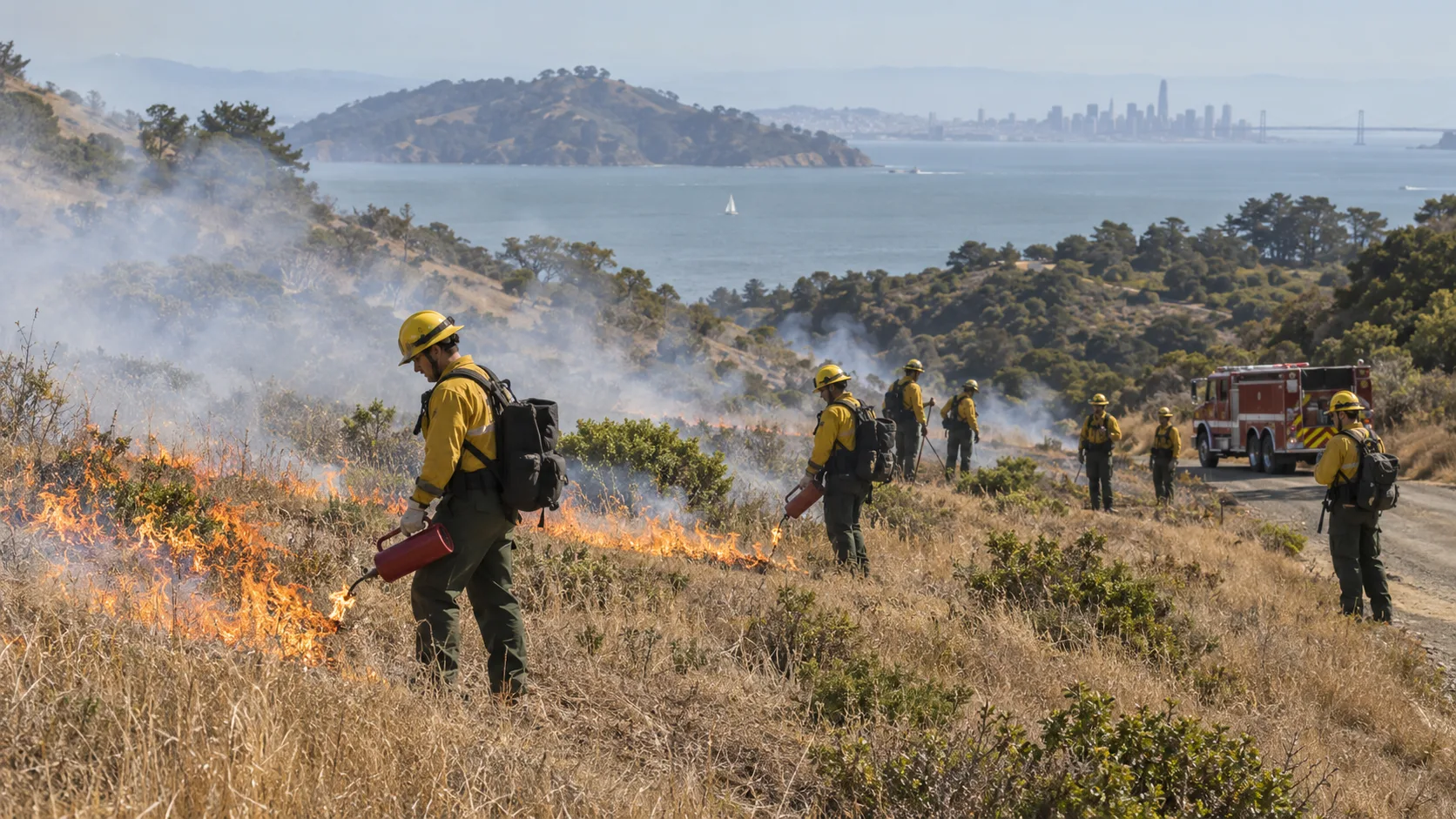
Prescribed fire is not the same as “letting a fire burn.” Ignition takes place under a written burn plan, with personnel, equipment, weather parameters and contingency actions established before the operation begins.
Why Is There So Much Smoke Over San Francisco Bay?
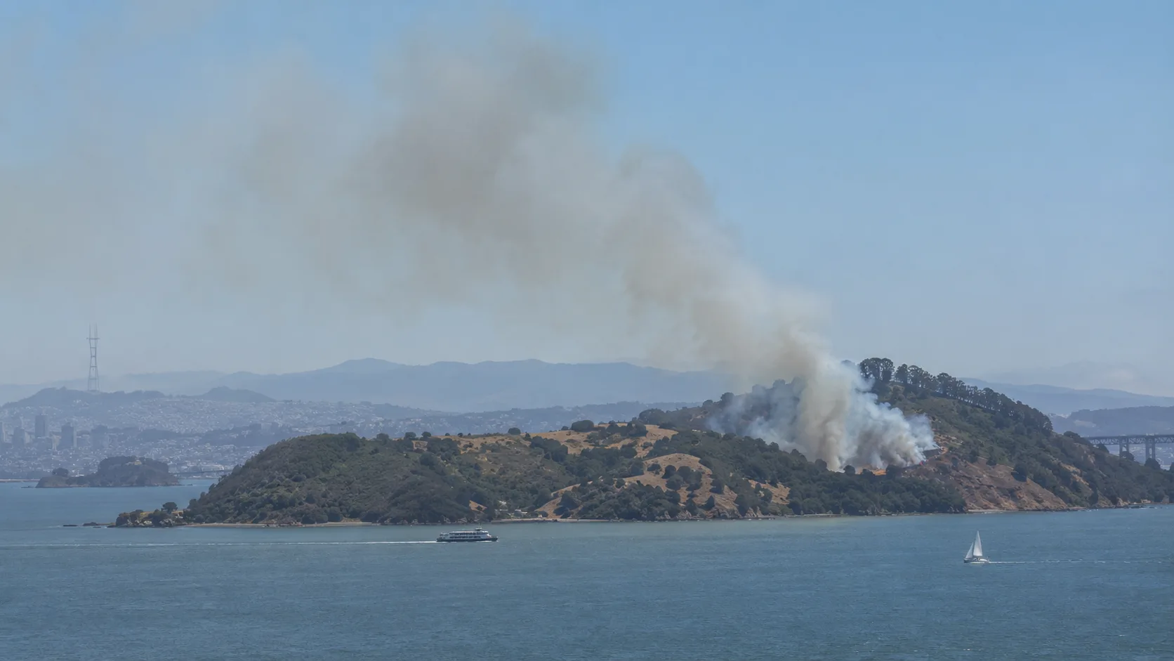
Angel Island sits in the middle of San Francisco Bay and is visible from a wide area. Even a controlled grass-and-scrub burn can therefore create a very prominent smoke column against the Bay Area skyline.
Officials warned before ignition that smoke could be visible from 9 a.m. to 6 p.m. on burn days. Some smoke or haze can remain visible around the island for up to three days after ignition.
Tuesday's plume was visible from multiple Bay Area communities and generated immediate online reports from people looking toward the island from San Francisco and Marin County.
The burn is coordinated with the Bay Area Air Quality Management District. Ignition depends on weather and air conditions that allow smoke to disperse. If those conditions fall outside the burn prescription, operations can be postponed or stopped.
If you smell smoke: State Parks advises limiting time in smoky areas and using common-sense precautions to reduce exposure, especially if smoke is causing irritation.
Why Officials Say Not to Call 911 About Angel Island Smoke
Both California State Parks and Marin County issued an unusual but very clear request before the operation: do not call 911 simply because you see smoke coming from Angel Island during the prescribed burn.
The reason is dispatch capacity. A highly visible smoke column in the middle of San Francisco Bay can generate a large number of duplicate emergency calls from people who believe they are seeing an unreported wildfire.
Fire personnel already know about the planned operation. Residents should still call 911 for a genuine emergency, but expected smoke from the announced burn does not need to be repeatedly reported.
Is Angel Island State Park Open?
Yes. Angel Island State Park and its campgrounds remain open during the prescribed burn, but portions of the park close temporarily for operational and visitor safety.
Officials said temporary restrictions can include:
- portions of the Ida Trail;
- portions of the Sunset Trail;
- sections of park fire roads;
- sections of the Perimeter Road near operations; and
- access to the summit of Mount Livermore on some burn days.
Closures can remain in place for one to three days during and immediately after burning. Visitors should follow posted barriers and instructions from firefighters and park staff rather than relying on an earlier trail-status report.
How Can Crews Conduct a Prescribed Burn During Fire Season?
A prescribed burn is only ignited when managers believe conditions fall inside an approved operating window. Relevant factors can include temperature, relative humidity, wind direction and speed, fuel moisture, smoke dispersion, staffing and available suppression resources.
For Angel Island, California State Parks is working with CAL FIRE and Marin County Fire Department, while smoke planning is coordinated with the Bay Area Air Quality Management District.
California's residential burn suspensions do not automatically mean agencies cannot perform prescribed fire projects. Agency burns operate under separate plans, permits and coordination requirements.
The key distinction is control: crews intentionally apply fire to a defined treatment area while monitoring conditions and holding boundaries. If the weather or smoke conditions are not acceptable, ignition can be delayed or the burn can be rescheduled.
Angel Island Fire Video
Official video resource
California State Parks maintains a Prescribed Fire Videos & Media page with Bay Area prescribed-fire footage, including its 2026 prescribed burn season material and official YouTube players explaining broadcast and pile burns.
During this September 8 update, no reliable public YouTube upload specifically showing the 2026 Angel Island ignition was located. For that reason, this article does not populate the site's youtube_id field with an unrelated prescribed-fire clip.
News and social-media images from Tuesday do show the smoke column rising from the island, but those images and clips may be copyrighted or licensed. They should not be copied into the article without permission.
Where to Get Official Angel Island Burn Updates
- California State Parks — Prescribed Burn Planned at Angel Island State Park — official project scope, smoke guidance, closures and agency partners.
- Angel Island State Park current conditions — park restrictions and current smoke advisory.
- Marin County Fire Department / Marin County release — local public-safety details and contact information.
- California State Parks — Prescribed Fire Videos & Media.
- California State Parks — Bay Area District Prescribed Fire Program — background on the program and prescribed-fire history.
California State Parks also recommends following the Angel Island park webpage and its social accounts, along with the Watch Duty app, for burn-status information.
Developing operation: “Up to 260 acres” is the planned treatment area, not a wildfire acreage estimate. The actual amount ignited on a given day can change with weather, fuel moisture and air-quality conditions.
Frequently Asked Questions
Is Angel Island on fire today?
Yes, but the visible fire is a planned prescribed burn, not an uncontrolled wildfire. The operation began September 8 and involves California State Parks, CAL FIRE and Marin County Fire Department.
Why is there smoke coming from Angel Island?
Crews are intentionally burning grassland and coastal scrub to reduce fuel, manage invasive vegetation and improve habitat. The smoke plume can be visible across much of San Francisco Bay.
How many acres are being burned?
The project is planned to treat up to 260 acres, depending on conditions.
Should I call 911 if I see Angel Island smoke?
No, not solely to report the expected smoke from this announced prescribed burn. Officials specifically asked the public not to overwhelm emergency dispatchers with duplicate smoke reports.
Is Angel Island closed?
No. The park remains open, although sections of the Ida Trail, Sunset Trail, fire/perimeter roads and Mount Livermore access can close temporarily.
How long will the smoke last?
Smoke can be visible during burn operations and some smoke may remain visible for up to three days afterward.
Is there a YouTube video of the Angel Island burn?
California State Parks has official YouTube-based prescribed-fire videos, but no reliable event-specific YouTube upload from the September 8 Angel Island burn was located during this update.
Editorial note: This article distinguishes a planned prescribed fire from a wildfire incident. The 260-acre figure is the maximum planned treatment area announced by officials, not an uncontrolled-fire perimeter. Information was checked against California State Parks, Marin County and current September 8 reporting.
Comments 0
No comments yet. Be the first to share your thoughts!
Leave a Comment